


Manuscript Collection
Mount Dearborn Map - Accession 347 - M137 (173)
Files
Identifier
Accession 347 - M137 (173)
Inclusive Dates
No Date
Restrictions
Open under the rules and regulations of the Louise Pettus Archives and Special Collections
Collection Size
1 piece
Language
English
Historical Note
Mount Dearborn, previously known as Rocky Mount, was the National Armory located on the Catawba River in Rocky Mount, SC from 1802-1829. Mount Dearborn was located just below the Great Falls (sometimes called Catawba Falls) on the Catawba River. After the Catawba River was dammed by Duke Electric the Great Falls no longer existed.
Scope and Content Note
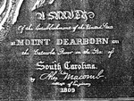
The Mount Dearborn Map is a photocopy of an 1809 contour map of Mount Dearborn in Chester County, SC including Fort Dearborn. Mount Dearborn, previously known as Rocky Mount, was the National Armory located on the Catawba River in Rocky Mount, SC from 1802-1829. Mount Dearborn was located just below the Great Falls (sometimes called Catawba Falls) on the Catawba River. After the Catawba River was dammed by Duke Electric the Great Falls no longer existed.
Provenance
The Mount Dearborn Map was donated by Fred Hambright to the Archives on September 5, 1980.
Copyright
For information concerning copyright please contact the Louise Pettus Archives and Special Collections at Winthrop University.
Finding Aid Citation
Louise Pettus Archives and Special Collections, Winthrop University, "Mount Dearborn Map - Accession 347 - M137 (173)". Finding Aid 373.
https://digitalcommons.winthrop.edu/manuscriptcollection_findingaids/373
LC Subject Headings
Catawba River (N.C. and S.C.)--Maps; Allotment of land--South Carolina--Maps; Catawba Indians--South Carolina--Maps; South Carolina--Maps