


Manuscript Collection
A Complete Map of North Carolina - Accession 1248 - M600 (653)
Files
Identifier
Accession 1248 - M600 (653)
Inclusive Dates
1966
Restrictions
Open under the rules and regulations of the Louise Pettus Archives and Special Collections
Collection Size
1 piece
Language
English;
Scope and Content Note
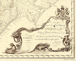
This collection consists of a 1966 reproduction of a 1770 map titled, “A compleat map of North Carolina from an actual survey” by Capt. John Collet, Governor of Fort Johnston and engraved by I. Bayly. The map of North Carolina showing mountains, counties, rivers, cities, lakes, and ports. The map was reproduced by the North Carolina State Department of Archives and History courtesy of William Patterson Cumming in 1966. It measures 56 x 85 cm.
Provenance
The Complete Map of North Carolina was transferred to the Archives from the Library's General Collection map cases.
Copyright
For information concerning copyright please contact the Louise Pettus Archives and Special Collections at Winthrop University.
Finding Aid Citation
Louise Pettus Archives and Special Collections, Winthrop University, "A Complete Map of North Carolina - Accession 1248 - M600 (653)". Finding Aid 779.
https://digitalcommons.winthrop.edu/manuscriptcollection_findingaids/779
LC Subject Headings
North Carolina--Maps--Early works to 1800; Landowners--North Carolina--Maps--Early works to 1800; Real property--North Carolina--Maps--Early works to 1800