


Manuscript Collection
World War I Map - Accession 1357 - M678 (733)
Files
Identifier
Accession 1357 - M678 (733)
Inclusive Dates
1918
Restrictions
Open under the rules and regulations of the Louise Pettus Archives and Special Collections
Collection Size
1 piece
Language
English; French;
Scope and Content Note
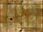
This collection consists of a map titled Carte de France et Des Frontieres which was printed at Base Printing Plant, 29th Engineers, US Army in 1918. The map is also labeled “No. 11 Longwy” and shows portions of Belgium, Luxembourg, Germany, and Meurthe-et-Moselle in Europe. This topographical map shows train routes and water routes and identifies cities, towns, and villages. The map was created during World War I by the Topographic Division of the American Expeditionary Force (AEF) due to a lack of adequate maps of the area before they arrived. This map most likely accompanied a military officer during the last year of the war.
Provenance
Unknown
Copyright
For information concerning copyright please contact the Louise Pettus Archives and Special Collections at Winthrop University.
Finding Aid Citation
Louise Pettus Archives and Special Collections, Winthrop University, "World War I Map - Accession 1357 - M678 (733)". Finding Aid 1007.
https://digitalcommons.winthrop.edu/manuscriptcollection_findingaids/1007
LC Subject Headings
Longwy (France)--Maps; Luxumbourg--Maps; Belgium--Maps; France--Maps