


Manuscript Collection
South Carolina Map - Accession 728 - M333 (385)
Files
Identifier
Accession 728 - M333 (385)
Inclusive Dates
1921
Restrictions
Open under the rules and regulations of the Louise Pettus Archives and Special Collections
Collection Size
14 pieces
Language
English;
Scope and Content Note
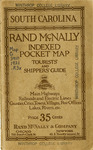
The South Carolina Map Collection consists of a South Carolina map produced by Rand McNally and is titled, Rand McNally Indexed Pocket Map Tourists' and Shippers' Guide of South Carolina. It was published in 1921 and includes information related to South Carolina "railroads, electric lines, post offices, express telegraph and mail service, counties, cities, towns, villages, rivers, lakes, islands, creeks, mountains, etc. air service landing fields, and population according to the latest official census."
Provenance
The South Carolina Map was given to the Archives by Dorothy Berry on October 19, 1988.
Copyright
For information concerning copyright please contact the Louise Pettus Archives and Special Collections at Winthrop University.
Finding Aid Citation
Louise Pettus Archives and Special Collections, Winthrop University, "South Carolina Map - Accession 728 - M333 (385)". Finding Aid 545.
https://digitalcommons.winthrop.edu/manuscriptcollection_findingaids/545
LC Subject Headings
South Carolina--Maps
Additional Notes
Map G 3910 .1921 .R3x