


Manuscript Collection
Files
Download Finding Aid (457 KB)
Identifier
Accession 1685 M816 (873)
Inclusive Dates
1851, 1856
Restrictions
Open under the rules and regulations of the Louise Pettus Archives and Special Collections
Collection Size
2 pieces
Language
English;
Scope and Content Note
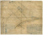
The Downtown Rock Hill Survey Plats consists of two plats laying out Main Street and downtown Rock Hill, SC on November 6 and 7th 1851 and November 26 and 27th 1856. Both surveys were conducted by John “Squire” Roddey, Esq. (1805-1860), Deputy Surveyor. These plats are the earliest known surveys conducted of Rock Hill, SC. These surveys were conducted to determine the layout of the new town as the Columbia and Charlotte Railroad built rail line and depot nearby beginning in 1848. Rock Hill would be founded in 1852 and incorporated in 1892. These plats offer an invaluable source for researchers interested in the founding of the city of Rock Hill.
Provenance
The Black Family Bibles were received from the York County Library via Jason Hyatt on August 8, 2019. The plats were originally donated to the Rock Hill Public Library by William Walter Miller, Sr. (1869-1945), a surveyor and civil engineer of Rock Hill and York County.
Copyright
For information concerning copyright please contact the Louise Pettus Archives and Special Collections at Winthrop University.
Finding Aid Citation
Louise Pettus Archives and Special Collections, Winthrop University, "Downtown Rock Hill Survey Plats - Accession 1685 M816 (873)". Finding Aid 1155.
https://digitalcommons.winthrop.edu/manuscriptcollection_findingaids/1155
LC Subject Headings
Rock Hill (S.C.)--History; Rock Hill (S.C.)--Surveys--Maps; City planning--South Carolina--Rock Hill--History--19th century