Manuscript Collection
State of South Carolina Map 1773 - Accession 1246 - M598 (651)
Files
Identifier
Accession 1246 - M598 (651)
Inclusive Dates
1970
Restrictions
Open under the rules and regulations of the Louise Pettus Archives and Special Collections
Collection Size
1 piece
Language
English;
Scope and Content Note
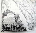
This collection consists of a 1970 reproduction of a map titled, “A map of the province of South Carolina [map] with all the rivers, creeks, bays, inlets, islands, inland navigation, soundings, time of high water on the sea coast, roads, marshes, ferries, bridges, swamps, parishes, churches, towns, townships, county, parish, district, and provincial lines. Humbly inscribed to the Honble. Lawlins Lowndes, Esgr. ... / by their most obedt. & faithful servt. Jams. Cook.” The map includes the following insets: A plan of Beaufort on Port Royal Island; A plan of Camden; A draught of Port Royal Harbour in South Carolina with the marks for going in; A plan of Charles Town; A chart of the bar and harbour of Charles Town;
Provenance
Transferred from General Collection.
Copyright
For information concerning copyright please contact the Louise Pettus Archives and Special Collections at Winthrop University.
Finding Aid Citation
Louise Pettus Archives and Special Collections, Winthrop University, "State of South Carolina Map 1773 - Accession 1246 - M598 (651)". Finding Aid 777.
https://digitalcommons.winthrop.edu/manuscriptcollection_findingaids/777
LC Subject Headings
South Carolina--Maps--Early works to 1800--Facsimiles; Charleston (S.C.)--Maps--Early works to 1800--Facsimiles; Georgetown (S.C.)--Maps--Early works to 1800--Facsimiles