


Manuscript Collection
State of South Carolina Map 1814 - Accession 1243 - M595 (648)
Files
Identifier
Accession 1243 - M595 (648)
Inclusive Dates
1814
Restrictions
Open under the rules and regulations of the Louise Pettus Archives and Special Collections
Collection Size
1 piece
Language
English;
Scope and Content Note
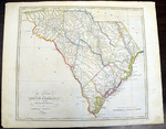
This collection consists of a map titled, “The state of South Carolina : from the best authorities / by Samuel Lewis ; W. Barker sculp” published by M. Carey, 1814. This topographical map of South Carolina with districts, rivers, cities, and counties labeled. The map measures 38 x 44 cm. on sheet 42 x 54 cm.
Provenance
Transferred from General Collection.
Copyright
For information concerning copyright please contact the Louise Pettus Archives and Special Collections at Winthrop University.
Finding Aid Citation
Louise Pettus Archives and Special Collections, Winthrop University, "State of South Carolina Map 1814 - Accession 1243 - M595 (648)". Finding Aid 774.
https://digitalcommons.winthrop.edu/manuscriptcollection_findingaids/774
LC Subject Headings
South Carolina--Maps