


Manuscript Collection
York County, S.C. Map - Accession 699 - M315 (366)
Files
Identifier
Accession 699 - M315 (366)
Inclusive Dates
1910
Restrictions
Open under the rules and regulations of the Louise Pettus Archives and Special Collections
Collection Size
1 piece
Language
English;
Scope and Content Note
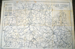
The York County, SC Map Collection consists of a map of York County, S.C. done by Jones and Walker of Rock Hill, S.C. The map shows the townships and school districts of the time, public roads, neighborhood roads, R.F.D. routes, telephone lines, railroads, transmission lines of the Southern Power Co. and individual residences. The map measures 28”X 38 ½” and is on a scale of 1” = 1 mile.
Provenance
The York County, S.C. Map was donated to the Archives by Joe S. Balthazer.
Copyright
For information concerning copyright please contact the Louise Pettus Archives and Special Collections at Winthrop University.
Finding Aid Citation
Louise Pettus Archives and Special Collections, Winthrop University, "York County, S.C. Map - Accession 699 - M315 (366)". Finding Aid 529.
https://digitalcommons.winthrop.edu/manuscriptcollection_findingaids/529
LC Subject Headings
York County (S.C.)--Maps