


Manuscript Collection
Rock Hill Land & Town Site Company Survey Map - Accession 1787 M842 (900)
Files
Identifier
Accession 1787 - M842 (900)
Inclusive Dates
1891
Restrictions
Open under the rules and regulations of the Louise Pettus Archives and Special Collections
Collection Size
1 piece
Language
English;
Scope and Content Note
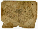
The Rock Hill Land & Town Site Company Survey Map collection consists of an original 1891 survey map produced by the Rock Hill Land & Town Site Company documenting the early planned development of Rock Hill, South Carolina. The map provides a detailed depiction of streets, avenues, and subdivided lots in what is now the central and eastern portions of the city, with particular emphasis on present-day Oakland Avenue and areas that later became part of the Winthrop University campus.
The survey illustrates prominent physical and institutional features of late-nineteenth-century Rock Hill, including the lot designated for the Presbyterian Boys School (later the Withers/WTS site), Oakland Park, and a large pond once located on land now occupied by Winthrop University. Transportation infrastructure is also documented, most notably the Electric Railway route running along Oakland Avenue and Lancaster Avenue (now Eden Terrace), as well as several historically significant roadways such as York Avenue (now Cherry Road). Together, these elements reflect the role of speculative land development, education, and transit in shaping Rock Hill’s urban growth during this period.
The map is associated with Alliene J. Cornwell, a recipient of a Domestic Arts certificate from the Winthrop Normal and Industrial College in 1915, and was preserved as part of her personal materials. As a primary visual record, this survey map is valuable for researchers studying Rock Hill’s nineteenth-century town planning, land use, and the early development of Winthrop and its surrounding neighborhoods.
Provenance
Rock Hill Land & Town Site Company Survey Map was originally owned by Alliene J. Cornwell and was given to the York County Library, which was later donated to the Louise Pettus Archives and Special Collections on May 16, 2022.
Copyright
For information concerning copyright please contact the Louise Pettus Archives and Special Collections at Winthrop University.
Finding Aid Citation
Louise Pettus Archives and Special Collections, Winthrop University, "Rock Hill Land & Town Site Company Survey Map - Accession 1787 M842 (900)". Finding Aid 1572.
https://digitalcommons.winthrop.edu/manuscriptcollection_findingaids/1572
LC Subject Headings
City planning--South Carolina--Rock Hill--Maps; Rock Hill (S.C.)--Maps; Rock Hill (S.C.)--History--19th century