


Manuscript Collection
York County Map 1825 - Accession 1443 - M707 (763)
Files
Identifier
Accession 1443 - M707 (763)
Inclusive Dates
nd
Restrictions
Open under the rules and regulations of the Louise Pettus Archives and Special Collections
Collection Size
1 piece
Language
English;
Scope and Content Note
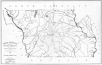
This collection consists of facsimile of Robert Mills 1825 map of York District, South Carolina. The map was surveyed by Gordon Moore, 1820 and engraved by H.S. Tanner & Assistants.
Provenance
The York County Map 1825 was owned by Ross Webb and given to the Archives on May 15,2013.
Copyright
For information concerning copyright please contact the Louise Pettus Archives and Special Collections at Winthrop University.
Finding Aid Citation
Louise Pettus Archives and Special Collections, Winthrop University, "York County Map 1825 - Accession 1443 - M707 (763)". Finding Aid 1076.
https://digitalcommons.winthrop.edu/manuscriptcollection_findingaids/1076
LC Subject Headings
Real property--South Carolina--York County--Maps; York County (S.C.)--Maps
Additional Notes
Housed in Manuscript Oversize (Drawer 24, Folder 96, Item 649).