


Manuscript Collection
Southeastern United States Map 1806 - Accession 1244 - M596 (649)
Files
Identifier
Accession 1244 - M596 (649)
Inclusive Dates
1806
Restrictions
Open under the rules and regulations of the Louise Pettus Archives and Special Collections
Collection Size
1 piece
Language
English;
Scope and Content Note
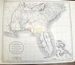
This collection consists of a reproduction of a map titled, “A New Map of Part of the United States of North America containing the Carolinas and Georgia. Also The Floridas and Part of the Bahama Islands &c. From the Latest Authorities by John Cary, Engraver 1806.”
Provenance
Transferred from General Collection.
Copyright
For information concerning copyright please contact the Louise Pettus Archives and Special Collections at Winthrop University.
Finding Aid Citation
Louise Pettus Archives and Special Collections, Winthrop University, "Southeastern United States Map 1806 - Accession 1244 - M596 (649)". Finding Aid 775.
https://digitalcommons.winthrop.edu/manuscriptcollection_findingaids/775
LC Subject Headings
Southern States--Maps