


Manuscript Collection
State of South Carolina Map 1796 - Accession 1240 - M592 (645)
Files
Identifier
Accession 1240 - M592 (645)
Inclusive Dates
1796
Restrictions
Open under the rules and regulations of the Louise Pettus Archives and Special Collections
Collection Size
1 piece
Language
English;
Scope and Content Note
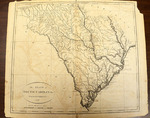
This collection consists of a map titled, “The State of South Carolina: from the best Authorities, 1796” and published by John Reid, New York. The map measures 39 x 44 cm. on sheet 41 x 56 cm.
Provenance
Transferred from General Collection.
Copyright
For information concerning copyright please contact the Louise Pettus Archives and Special Collections at Winthrop University.
Finding Aid Citation
Louise Pettus Archives and Special Collections, Winthrop University, "State of South Carolina Map 1796 - Accession 1240 - M592 (645)". Finding Aid 771.
https://digitalcommons.winthrop.edu/manuscriptcollection_findingaids/771
LC Subject Headings
South Carolina--Maps