


Manuscript Collection
Guide Maps to Development of S.C. Parishes, Districts, and Counties - Accession 895 - M409 (460)
Files
Identifier
Accession 895 - M409 (460)
Inclusive Dates
1979
Restrictions
Open under the rules and regulations of the Louise Pettus Archives and Special Collections
Collection Size
11 pieces
Language
English
Scope and Content Note
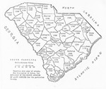
This collection consist of a copy of Guide Maps to Development of S.C. Parishes, Districts, and Counties compiled by the South Carolina Department of Archives and History from maps in SC County Inventories made by the WPA historical records survey. It includes copies of several maps of South Carolina including: Proprietary Counties of South Carolina 1682; Parishes of South Carolina 1770 compiled by Historical Records Survey, WPA, 1938; South Carolina Circuit Court Districts 1769 compiled by Historical Records Survey, WPA, 1938; South Carolina Counties & Circuit Court Districts A.D. 1785 compiled by Historical Records Survey, WPA, 1938; South Carolina Counties & Circuit Court Districts 1791-1799 compiled by Historical Records Survey, WPA, 1938; South Carolina Circuit Court Districts 1800 compiled by Historical Records Survey, WPA, 1938; South Carolina Counties 1868 compiled by Historical Records Survey, WPA, 1938; South Carolina County Origin Map;
Provenance
The Guide Maps to Development of S.C. Parishes, Districts, and Counties was deposited in the Archives on February 23, 1996.
Copyright
For information concerning copyright please contact the Louise Pettus Archives and Special Collections at Winthrop University.
Finding Aid Citation
Louise Pettus Archives and Special Collections, Winthrop University, "Guide Maps to Development of S.C. Parishes, Districts, and Counties - Accession 895 - M409 (460)". Finding Aid 625.
https://digitalcommons.winthrop.edu/manuscriptcollection_findingaids/625
LC Subject Headings
South Carolina--Maps