Manuscript Collection
York County Lease Holders Land Plat Map - Accession 549
Files
Identifier
Accession 549
Inclusive Dates
1983
Restrictions
Open under the rules and regulations of the Louise Pettus Archives and Special Collections
Collection Size
1 piece (69 3/4" x 48")
Language
English;
Scope and Content Note
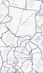
The York County Lease Holders Land Plat Map (69 ¾” x 48”) consists of a partial listing of people to whom grants of land, located in the Catawba Indian Boundary, were made by the commissioner of locations for York District, South Carolina during the years 1841-1842. Other grants were made upon expiration of leases as late as 1855 to surviving heirs, assignees, and transferees of earlier leaseholders. This map was prepared by Mr.& Mrs. J. Thomas Williams, Sr. from existing information obtained from plats on file in the York County Courthouse as of July 30, 1983.
Provenance
The York County Lease Holders Land Plat Map was donated to the Archives on December 14, 1983 by Mr. and Mrs. Thomas Williams, Sr.
Copyright
For information concerning copyright please contact the Louise Pettus Archives and Special Collections at Winthrop University.
Finding Aid Citation
Louise Pettus Archives and Special Collections, Winthrop University, "York County Lease Holders Land Plat Map - Accession 549". Finding Aid 464.
https://digitalcommons.winthrop.edu/manuscriptcollection_findingaids/464
LC Subject Headings
Land grants--Catawba Indian Nation--Maps; Land grants--South Carolina--York County--Maps