Manuscript Collection
Map of the Carolinas 1691 - Accession 1245 - M597 (650)
Files
Identifier
Accession 1245 - M597 (650)
Inclusive Dates
1691
Restrictions
Open under the rules and regulations of the Louise Pettus Archives and Special Collections
Collection Size
1 piece
Language
English
Scope and Content Note
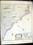
This collection consists of a reproduction of a 1691 map titled, “A New Map Of Carolina” by John Thornton, Robert Morden, and by Phillip Lea. The map includes an inset of Charleston, SC labeled, “A perticuler Map for the Going into Ashley and Cooper Rivers.” The map’s focus is on the coastline of North and South Carolina. The map is a reprint from the collection of the South Carolina Historical Society.
Provenance
Transferred from General Collection.
Copyright
For information concerning copyright please contact the Louise Pettus Archives and Special Collections at Winthrop University.
Finding Aid Citation
Louise Pettus Archives and Special Collections, Winthrop University, "Map of the Carolinas 1691 - Accession 1245 - M597 (650)". Finding Aid 776.
https://digitalcommons.winthrop.edu/manuscriptcollection_findingaids/776
LC Subject Headings
North Carolina--Maps--Early works to 1800; South Carolina--Maps--Early works to 1800; South Atlantic States--Maps--Early works to 1800