Manuscript Collection
Map of the Carolinas 1787- Accession 1242 - M594 (647)
Files
Identifier
Accession 1242 - M594 (647)
Inclusive Dates
1787
Restrictions
Open under the rules and regulations of the Louise Pettus Archives and Special Collections
Collection Size
1 piece
Language
French;
Scope and Content Note
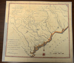
This collection consists of a map titled, “Caroline meridionale : avec les parties adjacentes pour servir à l'intelligence des mouvemens des armées Américaines et Britanniques.” The circa. 1787 map is in French and shows the movements of the British army and the America army through both North and South Carolina during the American Revolution. Battles and conflicts are marked on the map as well. Picquet is listed as the sculptor and the map measures 37 x 42 cm.
Provenance
Transferred from General Collection.
Copyright
For information concerning copyright please contact the Louise Pettus Archives and Special Collections at Winthrop University.
Finding Aid Citation
Louise Pettus Archives and Special Collections, Winthrop University, "Map of the Carolinas 1787- Accession 1242 - M594 (647)". Finding Aid 773.
https://digitalcommons.winthrop.edu/manuscriptcollection_findingaids/773
LC Subject Headings
South Carolina--Maps; United States--History--Revolution, 1775-1783--Maps