Manuscript Collection
Map of the Carolinas 1775 - Accession 1247 - M599 (652)
Files
Identifier
Accession 1247 - M599 (652)
Inclusive Dates
1966
Restrictions
Open under the rules and regulations of the Louise Pettus Archives and Special Collections
Collection Size
1 piece
Language
English;
Scope and Content Note
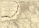
This collection consists of a 1966 reproduction of a 1775 map titled, “An accurate map of North and South Carolina with their Indian frontiers” by Henry Mouzon. The map shows Indian frontiers, mountains, rivers, swamps, marshes, bays, creeks, harbors, sandbanks and soundings on the coasts with the roads and Indian paths; as well as the boundary and provincial lines, the several Townships and other divisions of the land in both of the provinces. The map includes insets of Port Royal and Charleston. The map was reproduced by the North Carolina State Department of Archives and History courtesy of William Patterson Cumming in 1966. It measures 58 x 81 cm.
Provenance
Transferred from General Collection.
Copyright
For information concerning copyright please contact the Louise Pettus Archives and Special Collections at Winthrop University.
Finding Aid Citation
Louise Pettus Archives and Special Collections, Winthrop University, "Map of the Carolinas 1775 - Accession 1247 - M599 (652)". Finding Aid 778.
https://digitalcommons.winthrop.edu/manuscriptcollection_findingaids/778
LC Subject Headings
North Carolina--Maps--Early works to 1800; South Carolina--Maps--Early works to 1800; North Carolina--Administrative and political divisions--Maps--Early works to 1800; South Carolina--Administrative and political divisions—Maps--Early works to 1800; Charleston (S.C.)--Maps--Early works to 1800; Beaufort (S.C.)--Maps--Early works to 1800; Sea Islands--Maps--Early works to 1800