


Manuscript Collection
Map of the States of North and South Carolina 1784 - Accession 1216 - M581 (634)
Files
Identifier
Accession 1216 - M581 (634)
Inclusive Dates
1784
Restrictions
Open under the rules and regulations of the Louise Pettus Archives and Special Collections
Collection Size
1 piece
Language
English;
Scope and Content Note
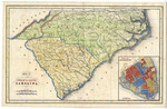
The collection consists of a map titled "Map of the States of North and South Carolina" that includes an inset entitled, “Plan of Charleston.” The map was engraved & printed by Fenner Sears & Co. and published in London by L.T. Hinton & Simpkin & Marshall, [1784?]. The map measures 16.5 x 10.5 inches.
Provenance
Transferred from General Collection: Maps (G3900 1784. F4x).
Copyright
For information concerning copyright please contact the Louise Pettus Archives and Special Collections at Winthrop University.
Finding Aid Citation
Louise Pettus Archives and Special Collections, Winthrop University, "Map of the States of North and South Carolina 1784 - Accession 1216 - M581 (634)". Finding Aid 767.
https://digitalcommons.winthrop.edu/manuscriptcollection_findingaids/767
LC Subject Headings
North Carolina--Maps; South Carolina--Maps