Manuscript Collection
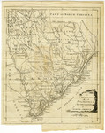
A New and Accurate Map of the Province of South Carolina in North America - Accession 1214 - M579 (632)
Files
Identifier
Accession 1214 - M579 (632)
Inclusive Dates
1799
Restrictions
Open under the rules and regulations of the Louise Pettus Archives and Special Collections
Collection Size
1 piece
Language
English;
Scope and Content Note
The collection consists of a map of South Carolina from the Universal Magazine of Knowledge and Pleasure, v. 64, April, 1799. Measures 11.5 x 14.5 inches. The map is titled: "A New and Accurate Map of the Province of South Carolina in North America."
Provenance
Transferred from General Collection: Maps (G3910 1779. N4 1799).
Copyright
For information concerning copyright please contact the Louise Pettus Archives and Special Collections at Winthrop University.
Finding Aid Citation
Louise Pettus Archives and Special Collections, Winthrop University, "A New and Accurate Map of the Province of South Carolina in North America - Accession 1214 - M579 (632)". Finding Aid 765.
https://digitalcommons.winthrop.edu/manuscriptcollection_findingaids/765
LC Subject Headings
South Carolina--Maps--Early works to 1800