Manuscript Collection
Map of North and South Carolina - Accession 1211 - M577 (630)
Files
Identifier
Accession 1211 - M577 (630)
Inclusive Dates
1796
Restrictions
Open under the rules and regulations of the Louise Pettus Archives and Special Collections
Collection Size
1 piece
Language
English;
Scope and Content Note
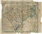
The collection consists of a hand colored map of North and South Carolina, ca. 1796. It measures 10.5 x 8.5 inches.
Provenance
unknown
Copyright
For information concerning copyright please contact the Louise Pettus Archives and Special Collections at Winthrop University.
Finding Aid Citation
Louise Pettus Archives and Special Collections, Winthrop University, "Map of North and South Carolina - Accession 1211 - M577 (630)". Finding Aid 762.
https://digitalcommons.winthrop.edu/manuscriptcollection_findingaids/762
LC Subject Headings
North Carolina--Maps--Early works to 1800; South Carolina--Maps--Early works to 1800