Manuscript Collection
Map of the Catawba River at Great Falls, South Carolina - Accession 1087 - M497 (548)
Files
Identifier
Accession 1087 - M497 (548)
Inclusive Dates
2002
Restrictions
Open under the rules and regulations of the Louise Pettus Archives and Special Collections
Collection Size
2 pieces
Language
English
Historical Note
Dearborn Island was the site of a national armory and arsenal from 1802 to approximately 1814.
Scope and Content Note
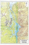
This collection consists of a map compiled in 2002 of the Catawba-Wateree River System and a topographical map of the Catawba River at Great Falls with explanations of various features on the reverse side which includes Great Falls Reservoir, Stumpy Pond, Dearborn Island, Fishing Creek Hydro and Dam, and Mountain Island.
Provenance
Gift of the Great Falls Home Town Association, Great Falls, SC
Keywords
Rivers, Hydro-electric power, Boat landings, Chester County SC, Great Falls SC, Catawba River
Copyright
For information concerning copyright please contact the Louise Pettus Archives and Special Collections at Winthrop University.
Finding Aid Citation
Louise Pettus Archives and Special Collections, Winthrop University, "Map of the Catawba River at Great Falls, South Carolina - Accession 1087 - M497 (548)". Finding Aid 715.
https://digitalcommons.winthrop.edu/manuscriptcollection_findingaids/715
LC Subject Headings
Catawba River (N.C. and S.C.)--Maps; Great Falls (S.C.)--Maps